Ecosystems:
OpenStreetMap
tortuOSMity
Calculates road-curviness from OpenStreetMap data using osm-qa-tiles and tile-reduce.
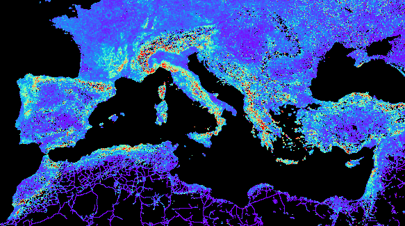
Here, the curviness is defined as the average quotient between road length and end-to-end beeline distance of each osm way tagged as a highway (primary, …, residential) in each zoom-level 12 mercator tile. Each pixel in the output corresponds to one of these tiles and is colored according from violet (where the length quotient is near 1 which means almost straight roads) to red (quotient >= 2).
how to
$ npm install
<install gnuplot, parallel, optipng, imagemagick>
$ node index.js "path to planet.mbtiles" > world.txt
$ gnuplot plot.gp
$ cd tiles
$ for i in {0..15}; do mkdir $i; done
$ convert ../world.png -crop 256x256 -set filename:tile "%[fx:page.x/256]/%[fx:page.y/256]" +repage +adjoin "%[filename:tile].png"
$ find -type f | parallel optipng
result
see also
Badges
Extracted from project README